Aberdeen Circular Trail
Aberdeen Circular Trail
Distance: 10.5 km
Time: 3 hours for normal hikers, 4.5 hours for families
Difficulty: 3/5 (Moderate)
Scenery: 4/5 (Wonderful Views)
Shelter: First half trail is sheltered, the last half trail has close to no shelter.
When to visit: Preferably Autumn and Winter (weather)
This trail is 10.5 kilometres and has the difficulty of 3 stars. This trail is recommended for hikers with some experience, especially in summer as the second half of the trail is unsheltered. It is recommended that you bring enough water especially if it's sunny.

1
2
3
4
5
Hong Kong Trail Sec.03
Aberdeen Reservoir Road
Aberdeen Nature Trail
Map and Elevation Chart (By Google Maps).
1: Starting Point/Ending Point (Peel Rise)
~Hong Kong Trail Sec.03
2: Aberdeen Upper Reservoir Main Dam
3:View Compass
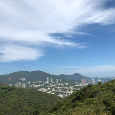
4:Aberdeen Colour Walks Scenery Point (No markings, but it has a good view of WCH)
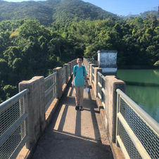
5: Aberdeen Lower Reservoir Main Dam
Detailed Description
This trail is challenging in two ways. One: The first and last thirds of the trail has little shelter. Two: The first and last thirds of the trail are also very steep. In short, the trail is hardest in these parts. The middle part (Hong Kong Trail Sec.03) was fine, but there is no breeze which makes it hot and the road has many small rocks that you need to almost always have your eyes on the ground. But overall, the trail is good, because its views are simply breathtaking; one of the best views on Hong Kong Island, following Tai Tam Reservoirs and Dragon's Back.
After you arrive at the starting point, you would head up the steep slope marked Peel's Rise. This road would lead you to the starting point of Hong Kong Trail Sec.03 and also Mount Kellet, near Victoria Peak. Heading up the road, you would go through a large cemetery, so some people would prefer to start from Mount Kellet. The road through the cemetery is fairly steep and has no shelter at all, which makes it the hardest part of the hike. But after the difficult climb, you would be rewarded with the woods. Remember to stay hydrated.
Following the road, you would soon reach Hong Kong Trail. At the intersection, turn right up the slope. This would be Section 3. But the slope is not as steep as before, and you would find this part easy. Continue walking on the road, you would reach a picnic site on the left where some people would have their lunch. Turn right into the small trail and you can relax, as this part of the trail is generally flat. Soon, after some ups and downs and (maybe) some complains about the heat, you would arrive at the midpoint of the trail. Continue on, and you would arrive at a small stream. Families could play around with the water (make sure your hands are clean) and cool down.
After picking up the bags and heading along again, you could catch glimpses of the Aberdeen Reservoir (but can't take photos of them, since the trees are blocking the view) and sooner than you would think, you would have arrived at the intersection where you there is a sign pointing to the Aberdeen Upper Reservoir. We would say to carry on, but some would like to take the short cut, since it saves a lot of steps. That does not mean saving a lot of energy, since if you continue on, the trail is still flat.
Very soon, you will arrive at the main road. Here, you can head downwards. This is the easiest part of the hike, and many families would walk there. After a couple of turns, you would be surprised to find hundreds of people gathering and you know that you have arrived at the Upper Aberdeen Reservoir. The reservoir is truly beautiful, its water being really clear. Adding on to the scenery is the forest behind.
After putting away your camera, head across the dam and go up the slope. Continue straight and turn right when you see the view compass sign. When you turn right, the road would slope steeply upwards, steeper than before in the cemetery. After taking a break at the top, you could head to the view compass, even though there is not much of a view. Continuing straight, you would gradually decrease in elevation. Turn right at the end of the road to the Lower Aberdeen Reservoir and not long after, you would come to a cliff, where you can savour spectacular views of Wong Chuk Hang beneath.
After spending a moment or two with your camera, turn right and head down the steep stairs, then make your way to the Lower Aberdeen Reservoir, last stop of the day. Even though not as beautiful as the Upper one, the dam itself can make up for it. There is less people too, so you could take perfect photos.
After you reach the end of the dam, turn left and continue straight. You would find yourself back at where you started, using the same transportation to go home, except that 3 or 4 hours has passed with great memories.


